

This report is divided into four parts;
- The first part provides a general overview of the Barrier route and its humanitarian implications. It also includes a brief overview of certain legal developments.
- The second part of the report is divided into geographic areas (from north-south) and provides a detailed description of the construction in each area along the route. A summary of key developments is provided at the beginning of each area section.
- Case studies are included throughout the report describing the Humanitarian situation of communities affected by the route of the Barrier.
- The final part of this report discusses access through the Barrier and provides a detailed description of the gates in the Barrier.
Introduction
Concerned that Palestinian livelihoods and access to essential services would be harmed by the construction of the West Bank Barrier, the international donor community - through the Humanitarian Emergency Policy Group (HEPG) - requested regular updates on the humanitarian impact of the Barrier. The HEPG comprises the European Commission and the EU President, the World Bank, USAID, Norway and UNSCO. This is the fifth such update and it is compiled by the UN Office for the Coordination of Humanitarian Affairs (OCHA) and the United Nations Relief and Works Agency (UNRWA) in the occupied Palestinian territory.
This report cannot do justice to all the humanitarian issues arising from the Barrier. It aims to provide an accurate account of its route and a general overview of its impact. The case studies seek to enhance understanding of the Barrier's impact on daily lives. Nevertheless, it is difficult to overstate the humanitarian impact of the Barrier. The route inside the West Bank severs communities, people's access to services, livelihoods and religious and cultural amenities. In addition, plans for the Barrier's exact route and crossing points through it are often not fully revealed until days before construction commences. This has led to considerable anxiety amongst Palestinians about how their future lives will be impacted.
Overview and Key Developments of the Latest Barrier Route
1. On 20 February 2005, the Israeli cabinet approved a revised route of the West Bank Barrier and published a map on the Ministry of Defense's website, (www.seamzone.mod.gov.il). The previous map was released on 30 June 2004.
In June 2002, the Government of Israel began construction of the Barrier following several suicide bombings and attacks by Palestinian militants on Israeli citizens. It maintains that the Barrier is a temporary structure to physically separate the West Bank from Israel to prevent such attacks on Israeli citizens.
2. An analysis of the map of the new route includes six categories: completed, under construction, planned, special security area, route subject to the completion of further inter-ministerial examination, and road protection.
3. Once completed, the total length of the new Barrier route will be 670 km long compared to 622 km of the previous route. This includes the sections around the Ma'ale Adumim settlement and Ari'el/Emmanuel settlement 'fingers' which are marked on the Ministry's map as, "subject to completion of further inter-ministerial examination". Together these two areas total 108 km or 16% of the route.
4. As of February 2005, approximately 209 km of the Barrier has been completed. This section consists of a combination of ditches, trenches, roads, razor wire, electronic fences and concrete walls. The Head of the Knesset Economics Committee estimated that the Barrier will cost $3.4 billion.
Analysis of Humanitarian Impact
Land affected
5. If the Ma'ale Adumim and Ari'el/ Emmanuel sections, marked as "subject to the completion of further inter-ministerial examination" are included, then approximately 57,056 hectares2 or about 10.1% of West Bank and East Jerusalem land will lie between the Barrier and the Green Line.
6. The previous Barrier route
Analysis of Humanitarian Impact
Land affected
5. If the Ma'ale Adumim and Ari'el/ Emmanuel sections, marked as "subject to the completion of further inter-ministerial examination" are included, then approximately 57,056 hectares2 or about 10.1% of West Bank and East Jerusalem land will lie between the Barrier and the Green Line.
6. The previous Barrier route incorporated 69,744 hectares or 12.7% of the West Bank and East Jerusalem. The 2.5% decrease in the land area located between the Green Line and the Barrier, is largely due to the shift of the Barrier back to the Green Line in the South Hebron area.
7. A larger decrease in affected land would occur, if the sections marked subject to completion of further inter-ministerial examination, Ma'ale Adumim and Ari'el/Emmanuel, were excluded. Then only 6.8% of West Bank and East Jerusalem land would be incorporated by the Barrier.
Palestinian population affected
8. The land between the Barrier and the Green Line constitutes some of the most fertile in the West Bank. It is currently the home for 49,400 West Bank Palestinians living in 38 villages and towns.3
9. The previous Barrier route had approximately 93,200 West Bank Palestinians living between the Green Line and Barrier. The reduction in population is due to an easing of the closures in Qalqiliya (population 45,800). While the city remains encircled by the Barrier, the checkpoint at the entrance of Qalqiliya is not manned.
10. Approximately 230,000 Palestinians hold East Jerusalem residency permits. About one-quarter of these people are located on the West Bank side of the Barrier and will need to cross the Barrier to access to services which they are entitled inside Jerusalem.
11. The Barrier will also affect those people living east of it who may need to cross it to get to their farms, jobs and services. More than 500,000 Palestinians, for example, live within a one kilometre strip of the Barrier.
Affect of the Planned Ma'ale Adumim Section
12. Extending 14 km east across the most narrow section of the West Bank, the planned Ma'ale Adumim section will impede movement between the northern and southern areas of the West Bank, blocking the current roads used by Palestinians to travel between these areas.
13. For Palestinians residing in and around East Jerusalem, the addition of the Ma'ale Adumim section will increase existing movement restrictions created by the constructed parts of the Barrier.
Barrier length
14. Stretching a total of 670 kilometres, the new Barrier route will run from the northern Jordan River in Eastern Tubas to the southern- most tip of the West Bank in the Hebron Governorate. Because of its meandering path into the West Bank, the Barrier's length is approximately twice the length of the 1949 West Bank Armistice Line adjacent to Israel, known as the Green Line – 315 km. The length of the Barrier will be 129 km less if the sections labeled "subject to completion of further inter-ministerial examination" are removed.
Departure from the Green Line
15. 20% of the Barrier's length runs along the Green Line. More of the Barrier is now planned to be on the Green Line primarily as a result of the shift of the southern route in Hebron towards the Green Line.
16. The Barrier's planned path extends into West Bank land in many places. In the planned Ari'el/Emmanuel finger, the Barrier extends 22 km or 42% across the width of the West Bank. In the planned Ma'ale Adumim section, the Barrier route extends into the West Bank 14 km or 45% of its width.
New Buffer Zone
17. In areas where the Barrier has been constructed, the IDF issued military orders in September 2004, creating a strip averaging 150-200 metres on the West Bank sides of the Barrier where new construction is prohibited.
New Buffer Zone
17. In areas where the Barrier has been constructed, the IDF issued military orders in September 2004, creating a strip averaging 150-200 metres on the West Bank sides of the Barrier where new construction is prohibited.
- close off the Gush Etzion (West Bethlehem) and Bir Nabala (North Jerusalem) areas.
Special Security Areas: These areas are marked in the Ari'el/ Emmanuel settlement fingers where some requisition orders have been issued and/or construction has begun along the planned route.
Access to jobs and services
18. Israel has taken a number of steps to facilitate Palestinian movement. It has constructed Barrier gates and built tunnels under roads restricted for Palestinian use, which connect Palestinian areas affected by the Barrier. However, these steps have not enabled Palestinians affected by the Barrier to fully resume their normal daily routines and movement.
19. Palestinians who live in "closed areas" are required to pass through gates in the Barrier to reach markets, schools, hospitals and maintain family connections in the remaining areas of the West Bank. Although Israel introduced some changes to the operation of the gates, access for Palestinians in these areas is restricted.
20. In February 2005, UN staff observed 63 gates in the constructed Barrier. Of these, 25 are accessible to Palestinians with the correct permit - two more since September 2004. The Israeli Government has not released information on which access gates will be opened through the planned routes of the Barrier.
This is particularly significant in the Jerusalem area, where tens of thousands of Palestinians remain uncertain as to how they will be affected.
Full report (pdf* format - 1.92 MB)
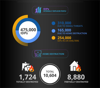
Israeli Assault on Gaza By Numbers in 30 Days
Date posted: August 09, 2014
By Safa Agency